You are here

Visualization

Why COVID-19 is more deadly in people with obesity—even if they're young

Since the pandemic began, dozens of studies have reported that many of the sickest COVID-19 patients have been people with obesity. In recent weeks, that link has come into sharper focus as large new population studies have cemented the association and demonstrated that even people who are merely overweight are at higher risk.

Problem, Solution, SitRep, or ?: 

Liberia - Access Constraints Map - 18 June 2015

                                                       (CLICK ON MAP IMAGE TO ENLARGE)


reliefweb.int - Logistics Cluster - June 23, 2015

CLICK HERE - reliefweb - Liberia - Access Constraints Map - 18 June 2015

CLICK HERE - Logistics Cluster - Liberia - Access Constraints Map - 18 June 2015

Country / Region Tags: 
General Topic Tags: 
Problem, Solution, SitRep, or ?: 

How Computer Modelers Took On the Ebola Outbreak

submitted by Sarah Slaughter         


At The Epidemic’s Epicenter: A Liberian child sits in an Ebola isolation ward housing people who might have contracted the contagious disease.  Photo: John Moore/Getty Images

Did real-time epidemic modeling save lives in West Africa?

spectrum.ieee.org - by David Brown - May 28, 2015

. . . “agent-based” models will give a more nuanced picture of how pathogens affect and sicken a population. “This is the wave of the future,” says Stephen Eubank, deputy director of the Virginia Tech lab. “It’s going to take a concerted effort to gather the data and the expertise. But it’s going to happen.”

And so, too, will another Ebola outbreak.

(READ COMPLETE ARTICLE)

Problem, Solution, SitRep, or ?: 

CDC - Mapping for Ebola: A Collaborative Effort


cdc.gov - January 14, 2015

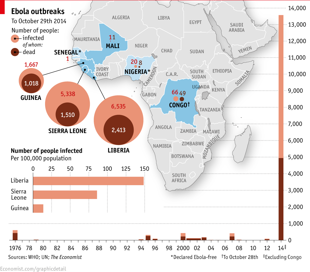
One of the difficulties faced by teams responding to the current Ebola outbreak in West Africa is identifying individuals and communities residing in remote areas. Existing maps of these regions either do not exist or are inadequate or outdated. This means that basic data like location of houses, buildings, villages, and roads are not easily accessible, and case finding and contact tracing can be extremely difficult.

To help aid the outbreak response effort, volunteers from around the world are using an open-source online mapping platform called OpenStreetMap (OSM) to create detailed maps and map data of Guinea, Sierra Leone, Liberia, and parts of Mali.

(READ COMPLETE ARTICLE)

Country / Region Tags: 
Problem, Solution, SitRep, or ?: 

The toll of a tragedy

An infographic of the toll of the Ebola outbreak.

Image: An infographic of the toll of the Ebola outbreak.

economist.com - October 31st 2014

The first reported case in the Ebola outbreak ravaging west Africa dates back to December 2013, in Guéckédou, a forested area of Guinea near the border with Liberia and Sierra Leone. Travellers took it across the border: by late March, Liberia had reported eight suspected cases and Sierra Leone six. By the end of June 759 people had been infected and 467 people had died from the disease, making this the worst ever Ebola outbreak.

(VIEW COMPLETE ARTICLE AND FULL SIZE INFOGRAPHIC)


General Topic Tags: 
Problem, Solution, SitRep, or ?: 
Subscribe to Visualization
howdy folks